
Europa 2018
Faroes – Considering the size of the Faroe Islands, it may seem quite strange that infrastructure, transport and logistics, have always constituted some of the islands’ biggest problems. Steep mountain terrain presented great difficulties to wayfarers, straits with violent currents and treacherous waters could only be crossed by strong and able-bodied mariners. There are many stories of perilous travels between the islands and accidents resulting in fatal outcomes during these voyages were not unusual. Travels between the islands presented such physical challenges that they were mostly reserved for men with strong constitution. The resulting isolation meant that even dialects were formed in one of the world’s smallest language area. These difficulties lasted until recent times. I personally remember meeting old people, especially women, who had never been outside of their islands of birth.
Around the turn of the 20th century, things started improving. There were scattered ferry connections between islands and settlements, and when the first automobiles arrived in the Faroe Islands in 1922 the need for expanding road infrastructure became apparent. In the late thirties, roads connecting towns and villages had come a long way, but it was still not possible to drive between the islands.
Connections between the two largest islands, Streymoy and Eysturoy, were particularly problematic. Although these islands lie very close to each other, car ferries were needed between Tórshavn and the populated areas of Eysturoy and the northernmost islands. A car ferry sailed regular routes between Tórshavn and Toftir on the eastern side of Skálafjørður, while a smaller ferry transported cars between Hósvík on Streymoy and Selatrað on Eysturoy. As the number of cars increased and waiting lines at the ferries grew longer – along with routes becoming unnecessarily long for the drivers – it was decided to build a bridge between the two major islands.
Streymin Bridge – The Bridge over the Atlantic
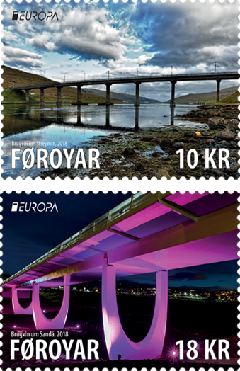
In March 1971, the construction and civil engineering company E. Phil & Søn began constructing a bridge between Eysturoy and Streymoy. The location chosen for the bridge was one of the narrowest stretches over “Sundalagið”, the channel separating the islands which had been dammed in the previous year. On the Streymoy side the bridge is located slightly south of the small settlement of Langasandur, while on the Eysturoy side the bridge lies between the towns of Norðskáli and Oyrarbakki. The place is called “Við Streymin” due to the narrowing of the strait which gives rise to violent ocean currents between the islands.
Building the bridge took a year and a half. It was 220 meters long and 9.5 meters wide, with a height of 17 meters. On October 30, 1973, it was officially opened for traffic. At first it only connected traffic northwards along the north-western side of Eysturoy, but three years later a large tunnel was opened connecting the bridge with the central part of the island along Skálafjørður with connections between Leirvík and the northern islands. 2006 saw the opening of a large sub-sea tunnel between Leirvík and Klaksvík, resulting in direct road connections between Kunoy, Borðoy, Viðoy and Eysturoy, Streymoy and Vágar.
The bridge “við Streymin” was the first step in a vast project intended to connect large parts of the Faroe Islands by roads. Every five years the bridge is inspected for wear and tear, and 2011 saw the completion of a comprehensive renovation and expansion of the bridge by foot- and bicycle paths.
The bridge, with its connected network of roads and tunnels, has had a major impact on the development of Faroese infrastructure and overall community development.
The Bridge over Sandá
While the bridge “við Streymin” connects islands, the bridge over “Sandá” is an entirely different story. The Sandá river, which runs from Havnardalur down to the sandy beach of Sandágerði, has since ancient times marked the border between Argir and Tórshavn, the capital of the Faroes. Argir was once a village, but the massive expansion of residential neighborhoods in the metropolitan area has resulted in the merging of these areas – so today Argir is one of Tórshavn’s largest suburbs.
But this was not always so. Argir – the name is derived from the Faroese word “ærgi”, summer pastures, – was uninhabited for a long time. In the 16th century, “Argja Hospital” became a leper colony – but when a smallpox epidemy in 1709 killed 12 of its 15 patients, the hospital was not used to any great extent. In 1826 it was decided to build a hospital in Tórshavn and two years later the Argir hospital with its appurtenant land was sold at an auction. The buyer was Andrass Mortensen, carpenter, ironsmith and stonemason – and in February 1829 he and his family took residence in Argir.
The First Bridges
Andrass Mortensen was a popular craftsman who travelled extensively for work in the Faroes. But he was confronted by a major obstacle – the river Sandá, which was difficult to cross via stepping stones, especially after periods of heavy rain. Sailing to Tórshavn was too much of a struggle for Andrass so he decided to build a bridge over Sandá. The authorities did not want to support the project financially, so in 1831 Andrass started building the bridge on his own. At first he received help from pastor Gad in the adjacent priesthood in Sandágerði, but Andrass worked mostly alone with his young sons who struggled with the massive boulders used for the foundation of the wooden bridge.
Andrass Mortensen’s bridge was completed in 1835 to the great relief of the residents in Argir – and also those living in the villages of Kirkjubøur and Velbastaður. For almost a century, the bridge provided the only passage over the river between Argir and Tórshavn – but the introduction of automobiles in the Faroe Islands called for a larger bridge. By the end of the twenties, a stone bridge was constructed a little further down to the sea, and in the sixties, a concrete bridge was built close by.
The New Bridge
Following the extensive expansion of residential areas in Argir, the pressure on the bridge constructed in the sixties became too much. The city council of Tórshavn therefore resolved to build a new modern bridge over Sandá – this time further up the valley. The project was conditioned upon the bridge not affecting the scenic environment along the banks of Sandá which meant that the bridge was raised high above the river with the bridge anchors far away from the banks.
In 2014, the construction company J & K Petersen started building the bridge and it was officially taken into use on 28 May 2016.
The bridge over Sandá is built of steel and concrete. It is 140 meters long and 14.5 meters wide with two lanes and a sidewalk / bicycle path. Its highest point is approx. 16 meters over the river. It is a substantial part of the landscape, but the elegant architecture and modern lighting enhance the visual impression, especially with the U-shaped columns, reminiscent of raised arms supporting the bridge.
There is a world of difference and almost two centuries between Andrass Mortensen’s bridge and the new Sandá bridge – but the spirit is the same: cohesion, initiative and expansion.
Anker Eli Petersen